
This article offers a strategic perspective and does not constitute legal advice.
Four weeks ago, on 23 July, WGIC published the Q3 2026 edition of the Geospatial Policy Scan – the quarterly exercise in which our Policy Development & Advocacy Committee tracks policy, regulatory, standards and strategy developments relevant to the geospatial sector and puts them side by side. The ink was barely dry before several dates in its pages moved from watchlist to present-tense reality.
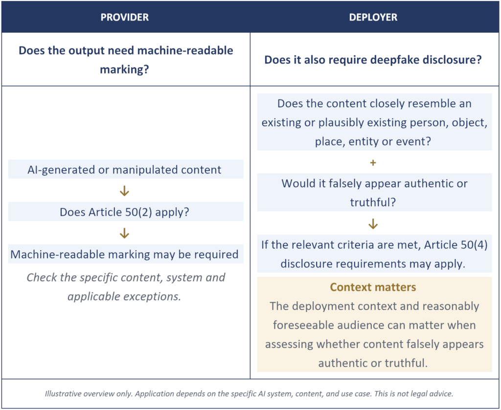
On 2 August, the EU AI Act’s Article 50 transparency obligations became applicable — this follows EU Commission guidelines published on 20 July that have direct relevance to geospatial applications. The guidelines clarify that certain AI-generated or manipulated digital twins can fall within the provider-side marking requirements of Article 50(2), subject to defined exceptions. Separately, the Act’s deepfake disclosure rule can apply to AI-generated or manipulated depictions of places when the cumulative criteria are met: the content must closely resemble an existing or plausibly existing subject and would falsely appear authentic or truthful. For our sector, that creates two distinct questions: when must an AI-generated geospatial output be machine-marked by the provider, and when must a deployer also disclose it as a deepfake? For the second question, context and the reasonably foreseeable audience matter; intent to deceive is not itself the legal test. In the same stretch, consultation windows we flagged in the edition closed. Weeks, not quarters: that is the tempo now.
Lauched earlier this year, the research done while compiling the WGIC Policy Scan twice now has been one of the most clarifying exercises of my career in this industry, because reading the rules side by side reveals a pattern no single headline shows. Geospatial policy has stopped being something that happens around our industry. It has become one of the forces designing the market itself. The four weeks since publication have only sharpened three shifts every geospatial leader should internalize.
Geospatial policy has stopped being something that happens around our industry. It has become one of the forces designing the market itself.
THREE SHIFTS RESHAPING GEOSPATIAL POLICY
The rules no longer arrive where we are looking
Many organizations still watch policy primarily through legislation. The familiar model is a bill moving through a legislative process, followed by time to adapt. That mental model is increasingly incomplete.
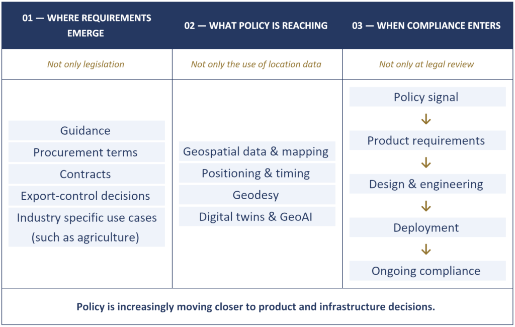
Some requirements with immediate operational effects for geospatial companies are not statutes at all. They can arrive through procurement clauses, export-control decisions, contract terms, and implementation guidance. Article 50 has been in the AI Act since 2024; the Commission’s July 2026 guidance clarified how the obligations apply in practice, including certain digital twins and AI-generated depictions of places. The shift is not always a new law. Often, it is the moment a known rule acquires operational detail or reaches an implementation date. A purchasing clause can reshape product requirements once it enters a contract; guidance can materially clarify how teams interpret compliance before the next legislative cycle. If your policy radar only scans legislatures, you are watching the front door while the rules come in through the loading dock.
The map itself is becoming regulated infrastructure
The second shift is easier to miss because it is happening underneath everything else: policy is increasingly reaching the foundational infrastructure that makes location possible. Oman, for example, adopted a National Geospatial Data and Information Law in 2026 that regulates geospatial data, mapping, surveying and related infrastructure. At the global level, UN-GGIM describes geodesy and the positioning and timing layer as underpinning modern economies and critical infrastructure, and its 2026 policy work identifies explicit inclusion of the foundational positioning and timing layer in national critical-infrastructure legislation and risk registers as an indicator of successful policy intervention.
For those of us who have spent careers explaining why location data matters, there may be vindication. But strategic importance cuts both ways. Strategic infrastructure can attract protection, licensing, localisation and access controls. Open data, shared models and cross-border services remain central to much of the geospatial ecosystem, but policy choices can affect how they are accessed, shared or used. That makes openness something to address explicitly in consultation rooms, standards bodies and policy design, not just celebrate in keynotes.
Openness is no longer just a principle; it is a policy design question.
Compliance is becoming a design discipline
The third shift is the one I would put in front of every product leader. Compliance is moving upstream. In many organizations, regulatory review has traditionally come late – a legal review before launch, a contract clause to negotiate. Increasingly, legal and policy requirements have to be translated into product decisions earlier. Across current laws, standards and procurement requirements, the questions can reach into what data trained a model, whether outputs carry machine-readable marks, how incidents are reported, and whether provenance can be demonstrated.
August’s transparency rules make the point concretely. Some key compliance questions now have to be answered in product and engineering decisions, not only in legal review. Is the output AI-generated or manipulated synthetic content, or simply observational data rendered without generative alteration? Does a digital twin fall within the guidelines’ narrow exemption for qualifying business-to-business or industrial contexts? If an image could constitute a deepfake, does it meet all of the relevant criteria, including resemblance and false appearance of authenticity or truthfulness in context? These are design and deployment questions. Addressing them only after launch can require additional controls or product changes. The implication is clear: policy can no longer sit solely with legal. It has to be read early, translated into requirements, and revisited as instruments move from proposal to obligation.
AI-GENERATED GEOSPATIAL CONTENT: TWO ARTICLE 50 QUESTIONS
From spectator to participant
If the rules are being written now, the interesting question is who is in the room. When consultations or standards processes touch AI systems used in Earth observation, positioning, digital twins or synthetic imagery, who is explaining how those systems actually work? The consultations we flagged in the Q3 edition – on high-risk AI guidance and on procurement terms – have now closed. That reinforces the value of direct technical input from geospatial practitioners. Without such input, resulting guidance or requirements may not fully reflect how these systems operate in practice.
This is the real case for systematic policy monitoring, and it is why WGIC invests in the Policy Scan. Not compliance anxiety – agency. It is far harder to shape rules once they have hardened. An industry that reads policy early, together, can show up while the text is still being written: in consultations, in standards working groups, in the quiet technical meetings where definitions get settled. An industry that reads policy late is more likely to be reacting than shaping.
It is far harder to shape rules once they have hardened.
Where to look next
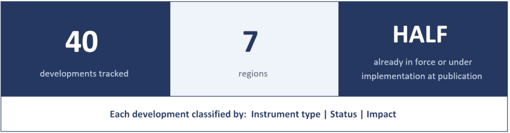
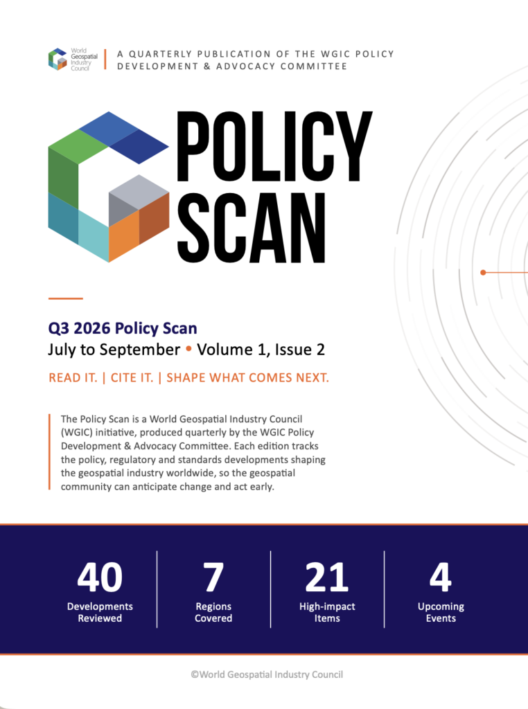
Perspective needs evidence, and that is what the Policy Scan is for. The Q3 2026 edition tracks 40 developments across seven regions, with half already in force or under implementation when we went to press, each labelled by instrument type, status and impact. Four weeks on, the AI Act’s 2 August applicability milestone has passed, and the high-risk AI and GSA consultation windows have closed. That reinforces the central premise: policy does not move on a quarterly publishing schedule. The Article 50 guidance and other developments from this quarter are being tracked for Q4.
Q3 2026 POLICY SCAN AT A GLANCE
Our ask of industry colleagues is simple. Read the Scan the way you would read a market report, because that is what policy has become: market intelligence. Bring it to product meetings, not just legal reviews. And when the next consultation opens that touches our field, respond – or tell us at WGIC so the Council can help bring practical geospatial evidence into the discussion.
The rules of location are being written now. The question is whether we help hold the pen.
The WGIC Geospatial Policy Scan is produced quarterly by the Policy Development & Advocacy Committee. Read the Q3 2026 edition (Volume 1, Issue 2), cite it and help shape what comes next.
Stay ahead of the policies shaping the geospatial industry.
Explore 40 key developments across 7 regions, understand their impact, and prepare for what comes next.