
policy-scan-2

Executive summary
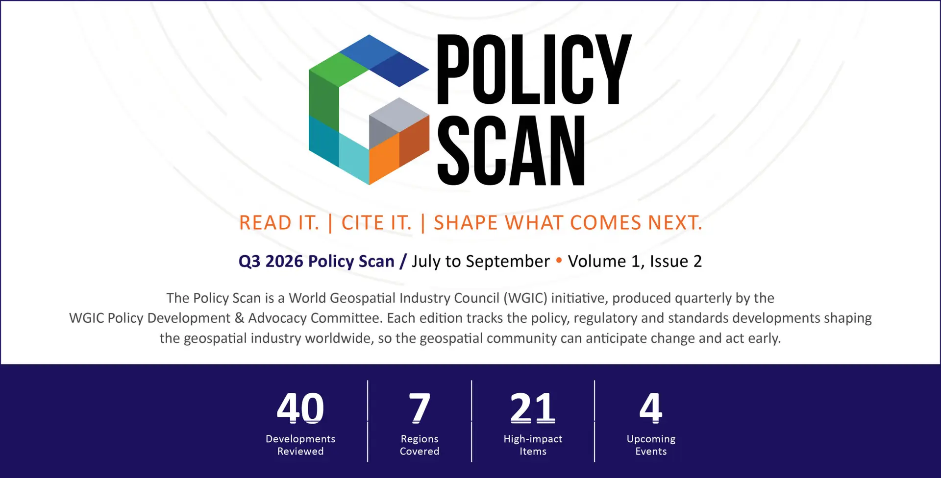
This edition tracks 40 policy and regulatory developments across seven regions, with the Middle East and Latin America entering scope for the first time. Half are already in force or in implementation and 16 are binding laws or regulations, marking a shift from monitoring emerging frameworks to meeting live obligations. Europe accounts for the largest share at 40 percent, followed by North America at 23 percent.
Five forces define the quarter: AI rules increasingly reach location data, with twelve developments engaging AI directly, including the EU AI Act; US procurement and export controls are emerging as de facto standards; European deadlines under the AI Act, the Cyber Resilience Act and the Data Act fall within weeks of each other; drones and Earth observation are gaining a clearer rulebook; and data sovereignty now extends well beyond China. Twenty-one of the developments are rated high-impact.
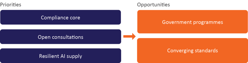
For the geospatial sector, the priority moves from awareness to operational readiness: building cross-jurisdictional compliance, engaging in open consultations, strengthening resilience in AI and data supply chains, while capturing the opportunities in government-led programmes and converging global standards.
This edition by the numbers
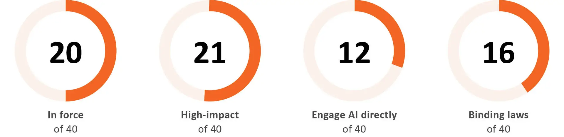
“Policies & laws” counts formal policy and regulatory developments of all kinds: Laws and regulations, executive actions, bills and drafts, standards, strategies and official guidance. Against the inaugural issue (27 policies · 5 regions · 12 high-impact), the field is considerably larger, and two regions join the inaugural five: the Middle East (Oman’s geospatial law) and Latin America (Brazil’s AI bill). Ecosystem and events are tracked separately, in their own section.
How the Q3 scan breaks down
By Instrument Type
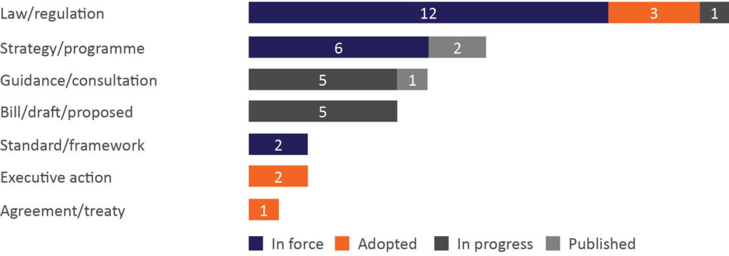
What it shows: The tracker captures more than binding law. Of the 40 developments in scope, 16 are binding laws or regulations. The other 24 are executive actions, bills and drafts, standards, strategies and official guidance.
By Region
A jurisdiction view of the same developments, mapped by country and market, accompanies this section so readers can see what applies where.
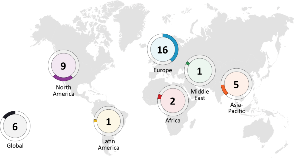
What it shows: Europe still accounts for the largest share (40%). North America’s 23% reflects more active US federal AI and procurement work, and Latin America appears for the first time, with Brazil’s AI bill.
By Domain
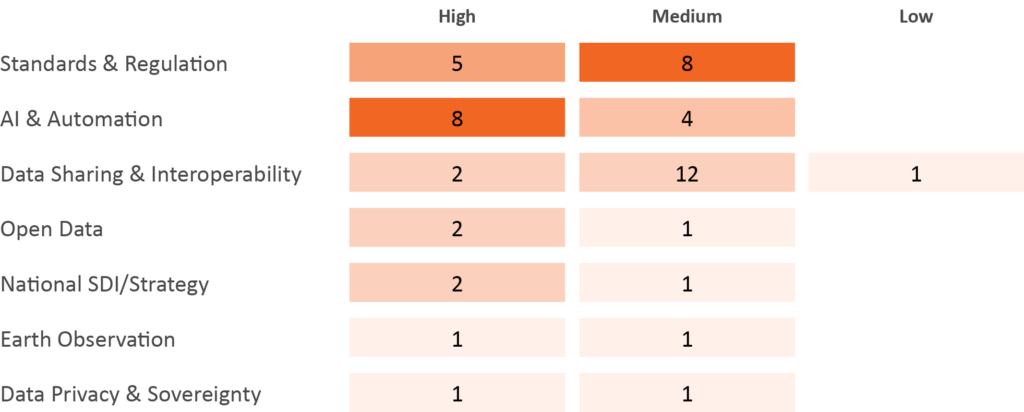
What it shows: Where the high-impact pressure sits. AI & Automation is the most high-impact-heavy domain (8 of 12 High). Darker cell = more developments.
Since Q2 2026
From the Q2 edition | Where it stands now (Q3 2026) |
EU AI Act | High-risk duties deferred to Dec 2027 and Aug 2028 under the Digital Omnibus; member-state sandboxes now due Aug 2027; the EC high-risk classification guidelines are out for consultation to 23 Jul. |
EU Space Act | IMCO amendments and a Council compromise agreed; adoption now expected around 2028, with application from 2030. |
INSPIRE | Reference Validator retired (1 Apr 2026); migration to High-Value Datasets under the Open Data Directive continues. |
FAA BVLOS (Part 108) | Final rule still pending as of June 2026; the earlier target date has passed. |
ASEAN DEFA | Negotiations substantially concluded; signing scheduled for November 2026. |
EU Digital Omnibus | Agreed on 7 May 2026; it reset the AI Act high-risk timeline. |
US AI policy | The White House National AI Framework has progressed to an AI Executive Order (2 June 2026), followed by export controls on Anthropic’s frontier models. |
Horizon Europe Space call (€90.97M) | Opened in March 2026 and still open as a funding route for the wider geospatial sector. |
UN GSGF, 2nd edition | Endorsed by the UN Statistical Commission in March 2026 and now moving into adoption. |
EU AI Continent Action Plan | Early milestones reported as delivered; implementation continues. |
Five themes shaping Q3
High-impact watch
Development | Region | Country / market | Status |
Binding law & regulation (11) | |||
White House Executive Order: Promoting Advanced Artificial Intelligence Innovation and Security5 | orth America | US | In force · Jun 2, 2026 |
US Export-Control Action on Anthropic Frontier AI Models6 | orth America | US | In force · Jun 12, 2026 |
EU AI Act: Digital Omnibus Agreement Delays High-Risk Rules7 | urope | EU | Approved · high-risk duties deferred to Dec 2027 / Aug 2028 |
FAA Part 108 BVLOS Rulemaking: Publication Target Update8 | orth America | US | Final rule pending |
FCC DJI Covered List Action: Dec 20259 | orth America | US | Approved · Dec 22, 2025 |
EU AI Act: General Applicability Milestone10 | urope | EU | In force · Aug 2, 2026 |
EU AI Act: Member State Sandbox Launches11 | urope | EU | In force · Aug 2, 2027 |
INSPIRE Reference Validator Retired & Directive Simplification Proposal12 | urope | EU | In force · Apr 1, 2026 |
EU Data Act: Connected-Products Data Obligations Effective Sep 12, 202613 | urope | EU | In force · Sep 12, 2026 |
Beijing Civilian Drone Sales & Flight Ban: Effective 1 May 202614 | sia-Pacific | China | In force · Apr 30, 2026 |
Oman National Geospatial Data and Information Law15 | iddle East | Oman | In force · Oct 6, 2026 |
Strategy & programme (3) | |||
INSPIRE Modernization & High-Value Datasets16 | urope | EU | In force · Apr 1, 2026 |
Horizon Europe 2026-2027: Destination Earth Large-Scale Pilots17 | urope | EU | In force |
Map Africa Initiative Launch18 | frica | Africa (regional) | In force · Jul 2025 |
Standards, guidance & consultation (6) | |||
EC Draft Guidelines on High-Risk AI Classification: GeoAI Implications19 | urope | EU | Consultation · Jul 23, 2026 |
EU Cyber Resilience Act: Q3 Standardisation Deliverables & Sep 2026 Reporting Obligations20 | urope | EU | In force · Sep 11, 2026 |
RICS Professional Standard: Responsible Use of AI in Surveying Practice21 | lobal | Global | In force · Sep 2025 |
EU Space Act: IMCO Amendments & Council Presidency Compromise22 | urope | EU | Consultation · Mar 24, 2026 |
GSA Proposed AI Clause 552.239-7001: Basic Safeguarding of Data within LLM AI Systems23 | orth America | US | Consultation · Jun 17, 2026 |
UN-GGIM Policy Brief 5: Sustainable Foundations for Digital Public Infrastructure24 | lobal | Global | Published · May 2026 |
Agreements & treaties (1) | |||
ASEAN DEFA: Substantial Conclusion; Signing Scheduled Nov 202625 | sia-Pacific | ASEAN (regional) | Approved · Oct 24, 2025 |
Implications for the geospatial industry
What matters for organizations across the sector is less the number of developments than three practical questions: what they must do, where they are exposed, and where the openings are.
A fourth question is continuity. Existing workflows and customer capabilities can stop working when providers or data owners close off access while they assess policy and technology changes. Organizations should map their dependence on third-party models and datasets and plan for continuity if access is restricted.
The compliance clock
Obligation | Who it affects | When |
EU AI Act high-risk duties | GeoAI in critical-infra, border, emergency, biometric uses | Annex III: Dec 2027 · Annex I: Aug 2028 (prepare now) |
EC high-risk AI guidelines | All GeoAI providers (scope clarity) | Consultation closes 23 Jul 2026 |
EU Cyber Resilience Act | Connected products: sensors, GNSS, EO platforms, software | Reporting from 11 Sep 2026 |
EU Data Act | Connected product & platform data holders | 12 Sep 2026 |
GSA AI procurement clause | Vendors selling AI to the US government | Comments 3 Aug 2026; terms thereafter |
RICS AI standard | RICS members / surveying firms (global) | In force now (9 Mar 2026) |
California AB 2013 | GenAI/foundation-model developers reaching CA users | In force now |
Korea AI Basic Act | Providers serving the Korean market | In force; local rep; fines ~2027 |
Oman geospatial law | Providers operating in / supplying Oman | Rectify by 6 Oct 2026 |
Is your GeoAI “high-risk”?
Classification depends on intended purpose, deployment context and whether the system falls under Annex I or Annex III use cases; the examples below are indicative, not legal advice.
Likely HIGH-RISK under the EU AI Act
Satellite/drone maritime-border surveillance flagging people; critical-infrastructure monitoring tied to safety (e.g. flood data driving road/lock control); emergency dispatch from wildfire models; biometric identification from imagery; safety-critical navigation.
Likely NOT high-risk
Purely environmental, land-use, agricultural or aggregate mapping that does not target identifiable individuals and is not a safety component, though documentation and transparency duties may still apply.
Opportunities this quarter
Q3 2026 watch list: active deadlines
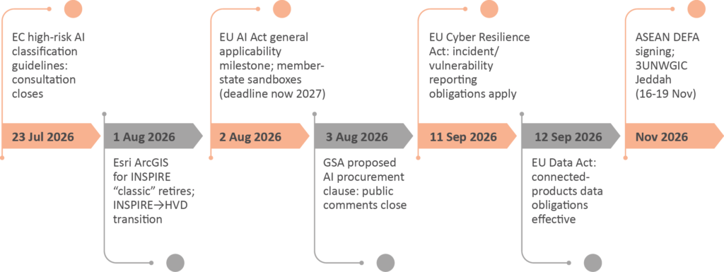
Ecosystem & events: the H2 2026 horizon

UN-GGIM 16th Session
- 5-7 Aug 2026
- New York
Sets the global geospatial governance agenda (UN-IGIF, global geodetic reference frame, data governance) that underpins national policy.

OGC Member Meeting
- 19-23 Oct 2026
- Cape Town
Where open geospatial standards, including GeoAI APIs, are advanced, shaping interoperability and compliance.

3UNWGIC
- 16-19 Nov 2026
- Jeddah
Premier UN geospatial congress; its programme and declarations steer global policy direction.
ITU AI-for-Good
- Ongoing, 2026
- Geneva
Year-round forum shaping norms and good practice for responsible geospatial AI.
Spotlights
WGIC Perspective
One theme deserves flagging: data sovereignty. Members have raised concerns that some public-sector bodies and data owners may restrict or pause access to open data and AI tools while they assess new rules and technology risks. For a sector that depends on open geospatial data and shared models, this access question may matter as much as the content of any single law. The Council is well placed to convene members on keeping data and tools usable across borders.
The Q3 policy landscape suggests geospatial policy is moving from lawmaking into implementation and enforcement. Three priorities follow:
- Help organisations across the sector build to the emerging common compliance core once (transparency, provenance, human oversight, incident reporting) rather than re-engineering for each jurisdiction.
- Engage the open consultations (EC high-risk guidelines; GSA clause) so the realities of GeoAI and Earth observation are reflected before rules harden.
- Champion interoperability and resilient, sovereignty-aware AI supply, so organisations are less exposed to the kind of sudden disruption the Anthropic episode highlighted.
Two opportunities stand out.
On the demand side, government programmes are creating stable, long-term procurement channels for geospatial and EO services integrated with AI. On the standards side, the convergence of the AI Act, GSGF, UN-IGIF and OGC API modernisation is creating an interoperable foundation the geospatial community is well placed to shape and to serve.
From awareness to operational readiness
Chair’s note
As Chair of WGIC’s Policy Development & Advocacy Committee, I am pleased to present, on behalf of the committee, the second edition of the Policy Scan. Geospatial intelligence continues to become foundational to how governments govern; economies operate; and societies respond to global challenges.
The Q3 2026 edition of the WGIC Policy Scan reflects a decisive shift in the global policy landscape, from monitoring emerging frameworks to actively implementing and enforcing them. With 40 tracked developments across seven regions, including new activity in the Middle East and Latin America, the scale and diversity of policy activity underscore the growing strategic importance of geospatial data, AI, and Earth observation. Notably, half of these developments are already in force or implementation, signaling that the sector must move beyond awareness to operational readiness and compliance.
A defining feature of this quarter is the deepening intersection between geospatial technologies and artificial intelligence regulation. From the EU AI Act and US executive actions to emerging frameworks in Asia and beyond, location data is increasingly within the scope of AI governance. At the same time, procurement rules, export controls, and national security considerations are shaping market access and technology availability as much as formal legislation. Alongside this, clearer regulatory structures are emerging for drones and Earth observation, while data sovereignty is becoming a global concern, extending well beyond traditional jurisdictions and raising questions about access to critical datasets.
Against this backdrop, the priorities for the geospatial community are clear. Organizations must build adaptable, cross-jurisdictional compliance capabilities; actively engage in open consultations to shape evolving rules; and strengthen resilience in AI and data supply chains. At the same time, there are significant opportunities, particularly government-led programmes and the convergence of global standards—to help define interoperable, responsible, and scalable geospatial ecosystems. WGIC is uniquely positioned to convene stakeholders, align industry perspectives, and ensure that policy evolution supports both innovation and sustainable growth across the sector.
Thank you for reading,
Best wishes,
Prof Dr Zaffar Sadiq Mohamed-Ghouse
HonFGCA · FRGS · FIEAust · NGPF · SMIEEE · MAICD
Chair, Policy Development & Advocacy Committee, World Geospatial Industry Council
Vice President & Director, Advisory & Innovation, Woolpert
Editor’s note
This quarter marks a turn. Of the 40 developments we track, half are already in force and 16 are binding laws or regulations, so the field has moved from watching emerging frameworks to meeting live obligations. If there is one thing to take from this edition, it is that geospatial policy has become an operational concern rather than a horizon-scanning one.
A few patterns are worth carrying forward. AI rules increasingly reach location data: twelve developments engage AI directly, and a model trained on imagery or basemaps can now fall within scope in markets such as the EU, California and Korea. Procurement and export powers, from the GSA AI clause to the Anthropic controls, are quietly setting de facto standards by deciding which tools the sector can use at all. Europe’s deadlines are stacking up, with the AI Act, the Cyber Resilience Act and the Data Act landing within weeks of each other in the second half of 2026. And data sovereignty is no longer a China story, with Oman’s geospatial law and UN-GGIM’s treatment of geodesy as critical infrastructure showing the question going global.
This is also where an industry perspective can add value. As these rules take shape, WGIC aims to support its members by reflecting industry views and encouraging policy that leaves room for both innovation and responsible, sovereignty-aware growth. Where consultations are open, there is an opportunity for the sector to contribute, and where standards are converging, industry input can help inform them.
Use this edition to anticipate what is coming and to act early. The organisations that treat this quarter as a readiness exercise, building to the common compliance core once, rather than jurisdiction by jurisdiction, will be the best placed as the rules harden.
All sources are listed in the References section.
Kuhelee Chandel
Editor, WGIC Geospatial Policy Scan
References
1. South Korea AI Basic Act. msit.go.kr
2. California AB 2013: Generative AI Training Data Transparency Act. leginfo.legislature.ca.gov
3. UK CAA Drone Rules Overhaul: Operator/Flyer/Remote ID Mandatory. caa.co.uk
4. EU U-Space Services: Mandatory for Urban/Congested Drone Operations. easa.europa.eu
5. White House Executive Order: Promoting Advanced Artificial Intelligence Innovation and Security. whitehouse.gov
6. US Export-Control Action on Anthropic Frontier AI Models. csis.org
7. EU AI Act: Digital Omnibus Agreement Delays High-Risk Rules. consilium.europa.eu
8. FAA Part 108 BVLOS Rulemaking: Publication Target Update. faa.gov
9. FCC DJI Covered List Action: Dec 2025. docs.fcc.gov
10. EU AI Act: General Applicability Milestone. eur-lex.europa.eu
11. EU AI Act: Member State Sandbox Launches. consilium.europa.eu
12. INSPIRE Reference Validator Retired & Directive Simplification Proposal. knowledge-base.inspire.ec.europa.eu
13. EU Data Act: Connected-Products Data Obligations Effective Sep 12, 2026. digital-strategy.ec.europa.eu
14. Beijing Civilian Drone Sales & Flight Ban: Effective 1 May 2026. beijing.gov.cn
15. Oman National Geospatial Data and Information Law. decree.om
16. INSPIRE Modernization & High-Value Datasets. knowledge-base.inspire.ec.europa.eu
17. Horizon Europe 2026-2027: Destination Earth Large-Scale Pilots. research-and-innovation.ec.europa.eu
18. Map Africa Initiative Launch. esri.com
19. EC Draft Guidelines on High-Risk AI Classification: GeoAI Implications. digital-strategy.ec.europa.eu
20. EU Cyber Resilience Act: Q3 Standardisation Deliverables & Sep 2026 Reporting Obligations. digital-strategy.ec.europa.eu
21. RICS Professional Standard: Responsible Use of AI in Surveying Practice. rics.org
22. EU Space Act: IMCO Amendments & Council Presidency Compromise. oeil.europarl.europa.eu
23. GSA Proposed AI Clause 552.239-7001: Basic Safeguarding of Data within LLM AI Systems. federalregister.gov
24. UN-GGIM Policy Brief 5: Sustainable Foundations for Digital Public Infrastructure. un.org
25. ASEAN DEFA: Substantial Conclusion; Signing Scheduled Nov 2026. asean.org
26. UK MoD Restricted Airspace Around Defence Sites. gov.uk
27. Geospatial Data Act: FY2026 Biennial OIG Compliance Audits Underway. fgdc.gov
28. UK NUAR Implementation under the Data (Use and Access) Act. gdsgeospatial.blog.gov.uk
29. India Draft Civil Drone. civilaviation.gov.in
30. NATO Calls for AI-Enhanced Geospatial Intelligence Sharing Standards. breakingdefense.com
31. EO Data Access Diverging: G20 Open Satellite Data Partnership vs. National Restrictions. oecd.org
32. Brazil AI Bill (PL 2338/2023): Risk-Based AI Regulation. www25.senado.leg.br
33. FGDC SDI Modernization 2026-2027 Activities. fgdc.gov
34. Kenya Open Geo-Spatial Data for Development. opengovpartnership.org
35. EU-Morocco Digital Dialogue Launch. digital-strategy.ec.europa.eu
36. NGA Technology Strategy 2026. nga.mil
37. India UAM Policy Framework & BVLOS Corridor Operations. civilaviation.gov.in
38. US Officials Criticize EU Space Act as Regulatory Overreach. satellitetoday.com
39. OGC GeoAI Standards Roadmap & SampleML-AI/ML SWG Formation. ogc.org
40. EU Space Act: Adoption Timeline Clarified: Late 2028, Application 2030. europarl.europa.eu