
The article was originally published on Energy Central as part of the The Digital Utility – Nov/Dec 2023 Special Issue.
Effective development and management of a settlement, be it a village, town, metropolis, or an entire country, includes, among other aspects, the efficient planning and management of utilities. A utility is akin to a neural network of an inhabitation, requiring precise location information of all the nodes a.k.a., utility assets. While utilities historically relied on hardcopy maps, the past few decades saw them adopting geospatial technologies to locate and manage their assets. This progression involved the incorporation of tools like Computer-Aided Design (CAD) and databases to establish Automated Mapping/Facilities Management (AM/FM) systems. The landscape further evolved with data being gathered with advanced ground surveying techniques, high-resolution satellite imagery, aerial imaging, LiDAR, Ground Penetrating Radar (GPR), and building a Geographic Information System (GIS), which enabled integration with Supervisory Control and Data Acquisition (SCADA) and Enterprise Resource Planning (ERP). This evolution has ushered in a more sophisticated and streamlined approach to managing and operating the complex network of utility assets and its operations, marking the imperative to embark on the digital utility transformation journey.
Digital utility solutions are crafted from real-world, project-tested services and leveraged software, emphasizing spatial enablement and high configurability. Looking at the pace of technological advancement, we can observe an opportunity gap to improve key outcomes by deploying technologies and methodologies from successful use cases. The decreasing cost of cloud computing, increased availability of powerful machine-learning (ML) and Artificial Intelligence (AI) capabilities, evolving tools for persistent data issues, and enhanced intelligence in smartphones create consolidation opportunities for utility companies.
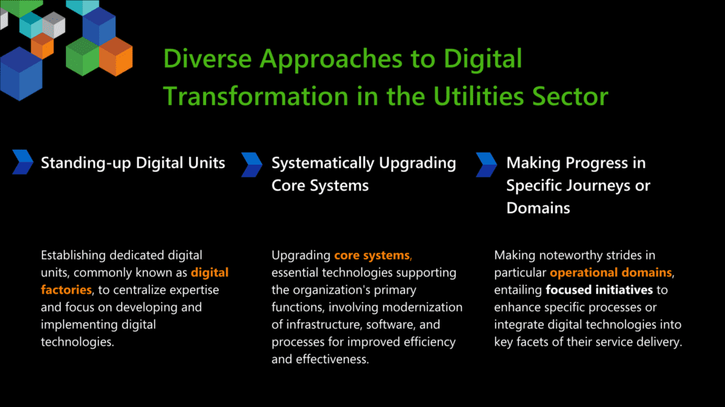
The utilities sector is actively engaging in digital transformation, but the approaches vary as depicted in Figure 1. The diversity in strategies reflects the fact that digital transformation is not a one-size-fits-all process; organizations may choose different paths based on their specific customer needs, operational challenges, and business goals.
Irrespective of the adopted approach, the case for digital utility is evident. McKinsey & Company when working with leading utilities, saw exceptional step-change improvements in select use cases such as a 25-30% field productivity improvement from AI-powered scheduling, up to an 80% capital reallocation based on ML insights in asset health, more than a 30% improvement on customer satisfaction in select journeys, and over 30% improvement in reliability and resiliency outcomes within existing spend levels.
This article delves into the power of geospatial data and technology as the driving force behind the digital transformation of power utilities. The use of geospatial solutions, along with emerging digital technologies, transforms the power utility management.
Maximizing Utility Infrastructure Efficiency Through Geospatial Data Integration
Ensuring a seamless link between customer demand and utility supply hinges on the physical infrastructure above, on, and/or below the Earth’s surface, demanding comprehensive documentation in a geospatial context. Through the integration of location data of assets with Information Technology (IT) and Operational Technology (OT) systems, a comprehensive dataset is created. In the words of David Totman, Director of Infrastructure Industry Strategy at Autodesk, a pioneer in geospatial solutions, “OT and IT systems can only be optimized with geospatial context at the macro and micro scales.” This geospatial context allows the utility company to understand basic operational maintenance activities such as timely monitoring of asset conditions as part of preventive maintenance routine and reduce unanticipated downtimes and improve asset life span.
Such integration facilitates management of overgrown vegetation around power lines and supports emergency response efforts by swiftly pinpointing affected areas, expediting response times and minimizing service disruptions. Further, geospatial data integrated into IT and OT systems optimizes energy distribution through demand pattern analysis, load balancing, and improves performance across the System Average Interruption Duration Index (SAIDI), Customer Average Interruption Duration Index (CAIDI), and Momentary Average Interruption Frequency Index (MAIFI) – indices used to measure the reliability of a power utility. In addition, geospatial integration streamlines decision-making processes by providing spatial insights, optimizing resource allocation, and supporting effective infrastructure planning for future expansions and upgrades.
While data integration is vital, uniformity is critical. Although network operators use databases across various functions such as vegetation management, asset management, and power flow monitoring, there is limited communication between these systems and their corporate GIS. “Regardless of the various systems used by utilities and suppliers, there needs to be uniformity in how data is received, viewed, and modeled – between providers and within the utilities themselves,” said Mike Battles, Senior Vice President & Market Director – Energy, Woolpert. The goal is to enable accurate real-time grid monitoring by overlaying geospatial data with live operational data taken from SCADA systems or online weather or wildfire monitoring sites. Utility end-users should benefit from product-agnostic connectivity to the data they need – when and where they need it. According to Chris Boreland, Global Lead – Power, Fugro, a leading geo-data solutions provider company, “this facilitates quick identification of faults, outages, or anomalies, allowing for faster response times and improved grid reliability.”
In the past few years, geospatial companies have started developing additional services that offer more analytics from remote sensing data like LiDAR and orthoimagery. With data integration and uniformity happening, a digital twin of the asset is created using which geospatial companies can align vegetation management, asset management, and power flow monitoring systems to a single asset twinned with the real-world asset, allowing for information sharing across the entire business.
Asset Visualization, Modeling and Management
In the dynamic landscape of power utilities, a comprehensive understanding of system inputs and outputs becomes imperative with a diverse array of energy generation sources such as solar, wind, hydropower and customer-generators, other attributes such as weather data becoming the norm along with evolving consumption patterns like residential electric vehicle (EV) stations. This involves a comprehensive visualization and analyses across spatial, temporal, and parametric dimensions to ensure uninterrupted power supply to customers.
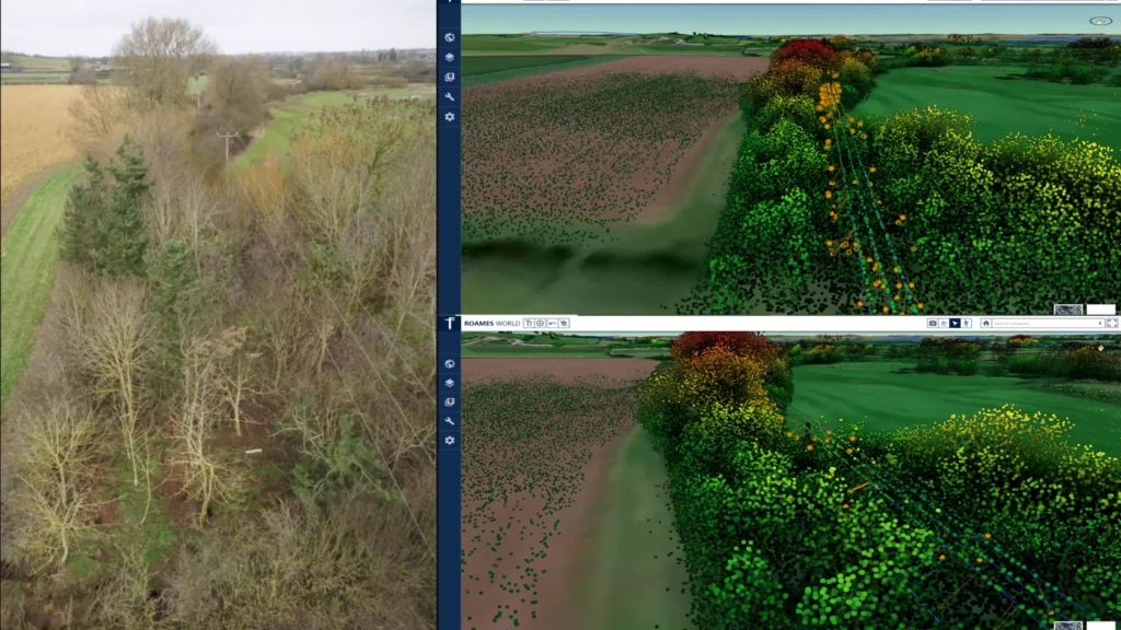
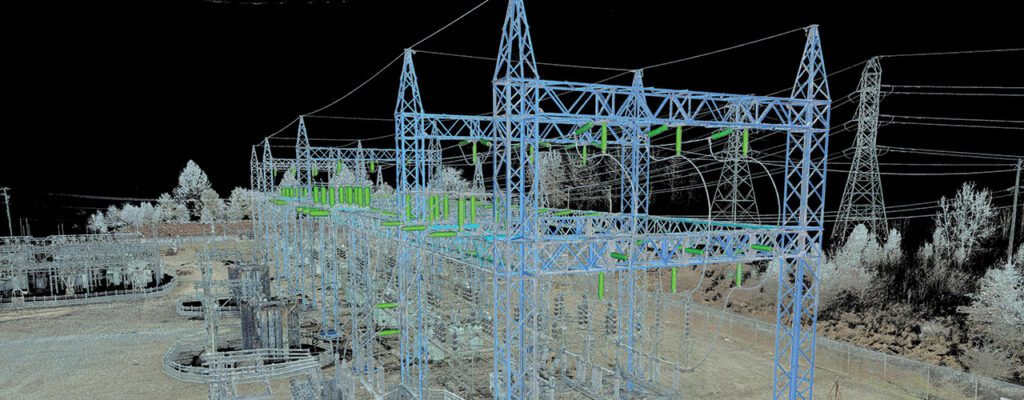
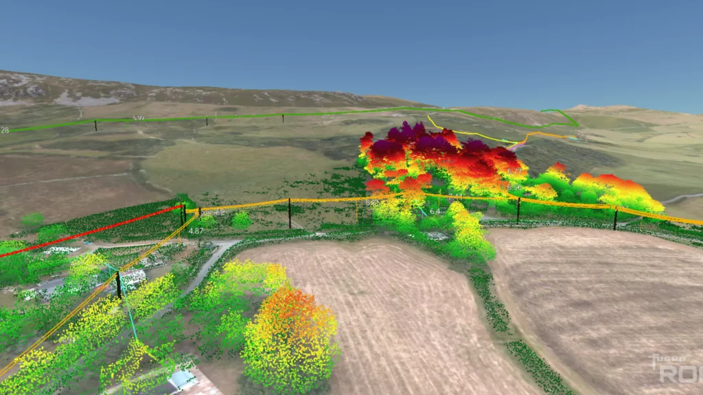
Fugro ROAMES®, for instance, visualizes asset information to help utility companies conduct desktop assessments of their network. This full-scale 3D network model or digital twin enables the incorporation of inputs like weather, network load, vegetation intrusions, and the spatial accuracy of the utility company’s GIS schematic. “By providing such visualization and analytics, utility companies have implemented digital inspection programs that have helped reduce their carbon footprint, inspection cycles, and operating expenses,” outlined Boreland.
Geospatial data of thousands of miles of assets obtained through specialized tools including LiDAR, high-resolution aerial and satellite remote sensing support utility companies with their mapping and modeling projects. On the ground, geospatial companies can also enable the modeling and management of terrestrial assets through laser scanning and mobile laser scanning. “This data can be then processed and modeled for utilities, including AI-powered data analysis, to enable owners and operators to make more informed decisions,” said Battles.
Effective asset analysis is integral to successful utility management. Corrosion and other environmental conditions can impede circuit flow, diminishing asset performance and potentially leading to conductor failure, causing outages. An essential metric in this analysis is the Asset Remaining Useful Life (RUL). RUL is a degradation analysis based on the decaying condition of an asset. The rate of degradation is inherently tied to the conductor’s in-situ environment. “Corrosion potential is a function of soil and ground moisture that vary widely across any given linear pathway of the circuit, thus determined by geospatial data taken into proximity context,” highlights Totman. For overhead circuits, the placement of lightning protectors includes aggregating lightning strike positioning with proximity and accessibility to overhead lines and equipment.
Geospatial technologies are crucial for efficient asset maintenance, particularly optimizing haul routes. Real-time mapping, spatial analysis, and predictive modeling provided by geospatial data empower power utilities to effectively plan and manage transportation logistics. This includes enhancing safety measures and minimizing environmental impact by leveraging precise spatial awareness and route optimization. For example, Woolpert survey crews use a vehicle-mounted Mobile Mapping System (MMS) to collect mobile LiDAR data along the selected haul routes. This data enables the utility client to determine the suitability of routes for the transportation of heavy machinery for the installation and repair of major electrical infrastructure. “Timely and accurate condition assessments of haul routes are imperative for maintaining positive relationships with landowners and government entities while avoiding litigation,” said Battles.
State-of-the-art positioning technologies along with augmented reality (AR) and 3D GIS geodatabases aid managers to “see” their assets beneath the ground or above at their exact location in 3D along with their surroundings simultaneously by rendering and simplifying the complexity of the 3D models. Such digital solutions powered by geospatial data offer a wide range of benefits for utility networks from asset inspection and fault determination to inspection detailing, fault reporting, job scheduling, asset management, workforce management and predictive maintenance of the assets.
Predictive Analytics and Digital Twins
Geospatial companies should align vegetation management, asset management, and power flow monitoring systems to a single asset twinned with the real-world asset, allowing for seamless information sharing across the entire business. Thus, “by drawing insights from the comprehensive datasеt, utilitiеs can idеntify patterns and trends, anticipate potential nеtwork issues, and proactively addrеss concеrns such as еquipmеnt failurеs, ovеrloads, or arеas suscеptiblе to outagеs,” says Elshan Musayev, Managing Director, and Mustafa Musayev, Project Manager at EKM Global Consulting GmbH, a geospatial company that believes in bridging the communication gap between utility companies and technology companies.
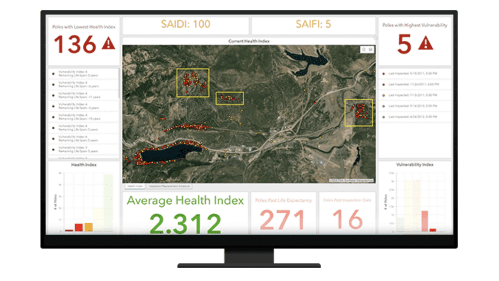
When a digital twin of, for example, a pole asset is created, asset managers can allocate maintenance data, inspection data, and information about other assets attached to the pole, such as design files and records. By merging information from these disparate databases, the utility company can better understand the asset’s condition, location, and importance.
The next step in the evolution of digital twins in the utility market involves taking this integration further. “The development of asset health indices will enable utilities to predict the anticipated lifespan of an asset, providing valuable information for decision-making on replacement timeframes and assisting with future budget calculations,” highlighted Boreland. For example, Woolpert’s predictive analytics merge high-resolution aerial and multispectral satellite imagery with historical data and current data sources, including cutting-edge sensors that remotely monitor and anticipate changing conditions. As dynamic data are collected, they are aggregated and fed through cloud-based machine learning algorithms that detect and predict designated outcomes. With these data, utilities can focus resources, determine the optimal timing and location of maintenance, and make informed and aligned decisions.
Increasing Demand for Up-to-date Geospatial Data
Access to real or near-real-time data enhances efficiency, saves both time and resources for the utility, along with fostering a significantly safer work environment. The timely availability of data ensures that ground crews can interact with the correct asset at the right moment, optimizing their operations.
The significance of up-to-date geospatial data is particularly pronounced in optimizing operational metrics, especially within the realm of monitoring and managing power infrastructure. “Globally, geo-enabled automation is proving to be an irreplaceable tool for demystifying utility ecosystem intricacies while providing “contextualized” insights,” says Agendra Kumar, Managing Director, Esri India. Consequently, there is a growing demand for such insights, recognizing its crucial role in advancing utility operations’ overall performance and safety standards.
Real-time data streams can be obtained through Earth-observing satellites, persistent observation sensors, and a multitude of geolocated IoT sensors, which provide additional layers of physical and cyber security. “In peaks and troughs of demand, having up-to-date geospatial data enables operators to have actionable insights for adjusting power loads and scheduling maintenance resources – in a more pragmatic and scheduled manner,” said Battles.
Extreme heat, winds, and floods are causing unprecedented power grid and network challenges. Having real-time data feeds is mandatory to effectively manage such extreme weather events. In any modeling of operational metrics, 100% of the system can be virtually modeled with science and engineering code. However, the model is only as accurate as the quality of the asset registry and understanding of existing boundary conditions.
“Where virtual and real differ, there is a need for calibration via real-time sensors. Most utilities only sensor up (SCADA) a portion of their system yet need to make decisions on 100% of their system, not just the portion that is sensored, so virtual models calibrated with real-time data enable the holistic decision-making environment and overall operational metrics,” outlined Totman.
Conclusion
In the fast-changing energy landscape, geospatial technology emerges as a silent architect for the digital transformation of power utilities navigating through the complexity of diverse operational scenarios. The integration of geospatial solutions represents a transformative leap, finely directing power utilities toward a resilient and sustainable digital utility future.