WGIC: What is your perspective on the increasing significance and need for industry-academia collaboration for the growth of the geospatial industry?
Ravada: In today’s landscape, we observe a widening gap between the knowledge students acquire in schools and what the industry demands from them when they enter the workforce. This gap transcends geographical boundaries and affects various segments within the geospatial industry.
The rapid integration of cutting-edge technologies such as artificial intelligence (AI), machine learning (ML), and advanced spatial software and hardware, including modern sensors, has further accentuated this chasm, which is only expected to increase with the rapid technology evolution. Against this backdrop, it becomes imperative to collectively cultivate a steady stream of talented students who are well-versed in the technologies vital to our field.
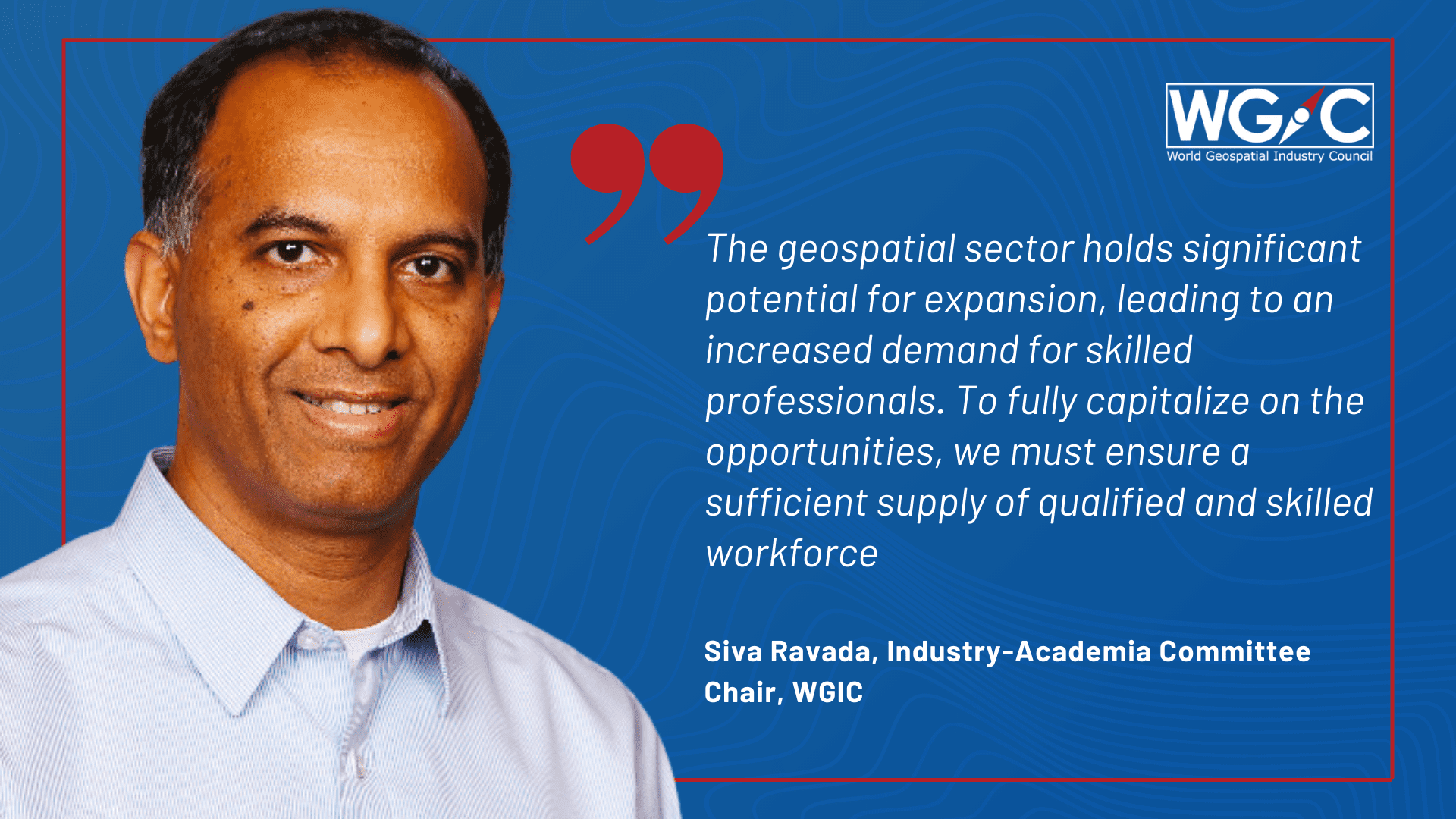
The geospatial sector holds significant potential for expansion, leading to an increased demand for skilled professionals. To fully capitalize on these opportunities, we must ensure a sufficient supply of qualified and appropriately skilled workforce. In light of this, it is crucial to proactively bridge this gap and align educational curricula with the industry’s evolving needs.
WGIC: What is the role of the Industry-Academia Committee in bridging this gap, and how is this in line with the mission of WGIC?
Ravada: At the core of the WGIC mission lies the pursuit of co-creating substantial business opportunities for the geospatial industry through collaborative programs. To realize this mission, we are focused on empowering the future workforce with the right skills and mindset, so they become invaluable assets for the geospatial industry.
WGIC: What are some of the issues the committee is addressing to leverage the strengths of higher learning institutions in meeting the needs of the geospatial industry?
Ravada: Our primary objective is to enhance communication and collaboration between the geospatial industry and academic institutions. There seems to be a lack of effective communication between these two entities, and we are committed to bridging this gap by fostering outreach and engagement.
One of the approaches we are taking is identifying real-world problems that can be solved using geospatial technology. We communicate these challenges to academic institutions and leverage their expertise to develop innovative solutions. Simultaneously, we aim to actively engage with universities to influence their academic curriculum. We can ensure that students build the necessary skills by aligning the course material with the industry’s needs.
Additionally, we recognize the importance of collaborating with educators throughout the 12-year school journey. Working together, we want to co-design programs that inspire and encourage students to pursue geospatial-related subjects when they go to college.
WGIC: According to you, what skills and knowledge would future geospatial graduates/professionals require?
Ravada: The geospatial industry seeks individuals with a diverse skill set encompassing technical and non-technical abilities and a solid geospatial background. During the hiring process, we often encounter students with either a computer science or a geosciences background, but rarely both. Having graduates equipped with robust computer science and geosciences expertise would be highly advantageous.
In recent applications, there has been a notable emphasis on user interface (UI) design and non-traditional geospatial solutions. This makes it imperative for students to acquire design-related user interface skills during their studies.
Besides vital technical skills, the industry requires individuals capable of advocating the benefits of spatial technology to diverse stakeholders, including government agencies at different levels. Additionally, in non-traditional spatial sectors like finance, banking, and insurance, there is a growing need for experts who can promote the significance of geospatial technology.
WGIC: How can WGIC leverage its network of members to promote knowledge-sharing and collaboration between academia and industry on a global scale, particularly in regions where the geospatial industry is still nascent?
Ravada: Our committee is relatively small at the moment. We are actively seeking to recruit more members from diverse geographic regions. By doing so, we aim to ensure good geographical representation, allowing us to encompass varied perspectives from around the world within our committee.
This enables us to reach out to geospatial communities in their respective geographies and identify universities for potential collaboration. The geospatial industry already benefits from a global workforce. These individuals possess valuable local contacts, and their experiences can prove invaluable in establishing connections with universities in less-developed regions.
Our goal is to leverage the collective strength of our global workforce and foster strong partnerships with local educational institutions. This network expansion will facilitate effective communication across different geographies and educational establishments, allowing us to advance the geospatial industry on a global scale collaboratively.
WGIC: Can you elaborate on the commitment made by WGIC to develop a repository of member offerings and collect best practices on geospatial industry internships for academia? What impact do you expect this to have on the growth and development of the geospatial industry?
Ravada: Our overarching plan revolves around creating a dynamic and interactive online registry, encompassing a comprehensive array of opportunities for new graduates offered by all WGIC members. These opportunities are in diverse domains, including software, hardware, sensor services, training, and public policy roles. Additionally, we aim to catalog internship opportunities WGIC members provide. We want to encourage WGIC members to offer more internships as they present an excellent starting point for students to gain practical experience while still in the university.
WGIC: The Committee intends to bring out a white paper on geospatial education and training in 2023. How will this bridge the gap between industry skill needs and academia’s ability to design curricula that meet industry needs?
Ravada: Our approach involves implementing several collaboration ideas, such as listing internships and organizing panel discussions to actively engage the academic community with WGIC members. By fostering this engagement, we aim to establish robust relationships that will enable us to contribute to curriculum development. Through these partnerships, we can share valuable insights about the skills and expertise the industry desires in new graduate and undergraduate students.
To initiate this process, we will focus on select geographies, including the US, Europe, and specific locations in India, collaborating with a limited number of academic institutions. The primary objective at this stage is to gain valuable insights from these pilot programs, experiments, and discussions. We will document the knowledge acquired from these endeavors to serve as a foundation for future initiatives.
We aim to replicate the success stories from these initial efforts in other regions. Doing so can encourage more educational institutions to actively participate in this transformative process. This expansion will lead to a broader network of engaged academic communities, reinforcing the relationship between academia and the geospatial industry.
WGIC: How is the committee promoting awareness through event outreach, campaigns, etc., to improve understanding of the importance of geospatial education and training?
Ravada: We have successfully organized a panel discussion during Geo Week 2023 in February in Denver. Kumar Navulur, our committee member and Sr. Director of Global Industry Business Development at Maxar Technologies, represented WGIC alongside other esteemed members from academia. The panel sparked a highly productive discussion on the significance of fostering collaboration between the geospatial industry and academia.
The success of this panel reinforced the value such discussions bring. We believe that hosting such insightful sessions at global and regional events will be instrumental in engaging additional academic institutions in these critical conversations.
We are actively exploring opportunities for collaboration with the United Nations Committee of Experts on Global Geospatial Information Management (UN-GGIM) academic network. This network has a wide-reaching global presence, especially in developing nations. By partnering with them, we aim to organize panels that actively engage with local academic institutions, forging meaningful connections.
Through these endeavors, we can initiate and nurture crucial conversations that pave the way for greater collaboration. By influencing academic curricula, we aim to prepare a well-equipped workforce to capitalize on the abundant opportunities that lie ahead as the geospatial industry continues to flourish.